Saw the unsettled, wet and mild theme of winter continue - warmer and wetter than average.
January was always going to be an improvement on December and indeed the January's of 2013+14 were both wetter than this January, but rain on 26 days in the month, relentlessly dull skies and with the month becoming wetter after a mid month lull, the sense of 'Will it ever end?' is now taking hold!
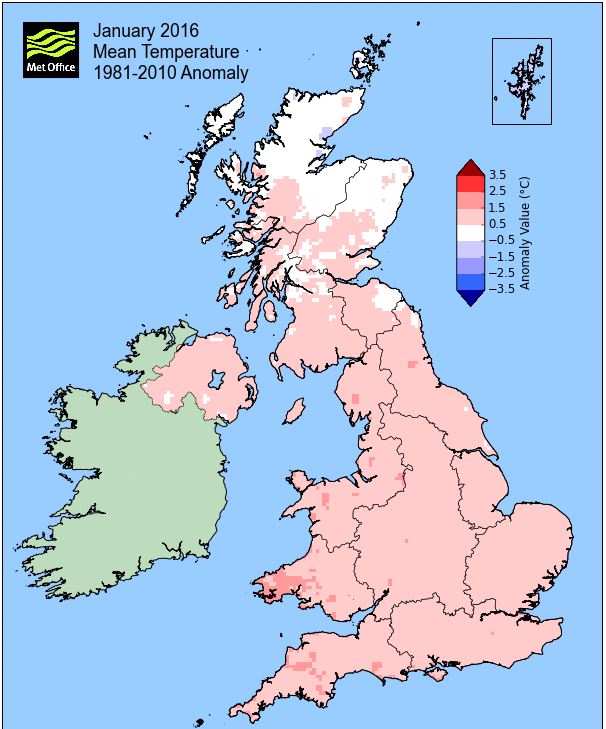
The month was mild and unsettled at both the start and end with a notable dip in temperatures around mid month, which also had a slight wintry flavour, but from the 22nd it became increasingly wet and very mild. After that cold snap mid month, the mean temperature for the month had dropped below average, but that mild end saw eight of the last ten days attain at least 10°c, along with some quite wet days, saw the month run out both warmer and milder than average.
MSLP of 1003.7 Mb was -8.4 Mb below the local average for January with low pressure in the ascendency, although during the 3rd-12th the pressure, whilst very low, sat more broadly over the UK, only becoming more mobile in that final third of the month.
Overall a mean minimum of 1.93°c and a mean maximum of 6.90°c saw the temperature 0.8°c above the 1981-2010 average and made it the warmest January since 2014. The highest maximum temperature recorded was 12.4°c (24th), the lowest minimum -5.5°c (16th).
Rainfall of 195.1 mm (Crosby Ravensworth School 234.1 mm and now for the first time, Castle Scar 237.8 mm [located between Crosby Ravensworth and Shap] and at Reagill 249.4 mm) made it the driest January since 2013 (the 5th wettest of the 9 recorded by myself) and here at Maulds Meaburn was 124.3 % of average for 2008-15. Locally rainfall ranged either side of 150%.
At the Met' Office site at Newton Rigg, 161.4 mm (159%) made it the wettest January since 2014 and in a series back to 1900 this makes it the 11th wettest in that time. A mean temperature of 4.55°c is the warmest since 2014 and in a complete series back to 1952 it is the 11th warmest (2 years having the same mean temperature).
Figures from the Environment Agency’s rainfall sites were, (figure in brackets being the monthly average for 1961-90) ‘Data kindly provided by the Hydrometry and Telemetry team of the Environment Agency (Penrith)’:
Kirkby Thore 97.4 mm (70.1 mm)
Brothers Water 474.18 mm (277 mm)
Nunwick Hall 129.4 mm (76.6 mm) and
541.4 mm at Seathwaite Farm (Borrowdale - 372 mm [average for 1981-2010])
1st - 2nd The year started with a frost as a slack flow over the UK brought light winds before an area of low pressure (LP) south-west of Cornwall moved ENE and introduced cloudier skies and some rain on the 2nd
3rd - 12th A broad area of LP then sat over or near to the UK during the period with the occasional occlusion bringing a dullness to the days and spells of rain, although rarely heavy.
As a consequence of the cloudy skies there was only a slight diurnal range in temperatures and which were above average, especially by night. Rain of 11.5 mm fell on the 3rd and 8.8 mm on the 6th, but it really was 'bits and pieces' and if you were out for more than an hour chances were that you would see some rain.
There was another slight frost on the 8th as the LP broadened further and we briefly stayed clear of any fronts, but the day then reverted to type with an occlusion bringing some rain. A band of more organised rain, 14.9 mm, arrived from the south during the evening of the 9th with pressure dropping to 968 Mb.
And through to the end of the period it remained the case of being in or near to the broad area of LP with the occasional occlusion bringing some rain.
13th - 17th A then suddenly a spell of wintry weather arrived. The dank, mild air was replaced by colder Arctic air and the winds turned N-NW and along with some spells of snow we had a few sharp frosts - but in reality, if this was to be 'winter', then it is a poor effort.
We had a little snow during tea-time on the 13th, but which turned back to rain and then back to snow overnight into the 14th, continuing during the morning with the day having a chilly feel.
High Pressure (HP) in the Atlantic was also building during this time and being clear of any fronts the 15th saw the first of several sharp frosts - and at last, some sun. Still under the influence of the HP, the 16th (Saturday) started with a month's low of -5.5°c (22.1°f) before an occlusion off the west coast of Scotland slowly drifted south and which with the pool of cold air already in-situ brought a spell of moderately heavy snow from 1445 Hrs and through the evening.
Fortunately it then didn't freeze overnight and some of the snow actually thawed, but we were still left with a cover of 5 cms on the morning of the 17th, but what a glorious start to the day. As the occlusion moved further south HP once again briefly re-established itself, before the same occlusion then moved back in the evening, but this time bringing a little light rain.
Footnote With only 0.1 mm of rain having been recorded on the 14th a record (for this site) 'Rain Spell' was brought to an end. On every day since the 23rd November upto the 13th January (52 days) rain of at least 0.2 mm was recorded on every day. Indeed the 22nd November was the only dry day in a longer period that had started on the 3rd November.
18th - 21st
We hung onto just enough snow on the 18th to give a second 'day of lying snow', but now the pool of cold Arctic air was steadily replaced by milder air from the south, although low pressure just off Cornwall was held at bay by HP over northern Europe.
This gave a few quiet but overcast days and at last, no rain and with the HP becoming more dominant both the 20th and 21st saw overnight frosts.
22nd - 25th The HP now finally gave way allowing LP in the Atlantic to move east. This brought a spell of heavy rain overnight into the 22nd which continued throughout the day.
However, the influence of the HP, now over northern Europe, was not finished as it now drew up a very mild and brisk south-westerly flow. Obviously this flow brought dank, murky conditions and the days whilst not particularly wet, were poor - but terribly mild. From the 22nd 10°c was attained on every day upto and including the 28th with a month's high of 12.4°c (54.3°f) on the 24th.
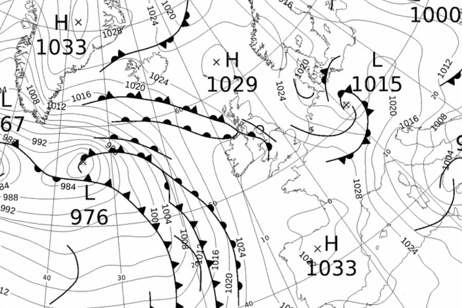
26th - 31st Over on the east coast of America a snow storm had been raging and once the weather system had done its work over there, it headed over here and arrived on the 26th. This was a deep area of LP that had been much modified by its journey across the Atlantic, but once here carried plenty of rain.
The rain arrived overnight into the 26th and continued heavily throughout the day to make the 26th the month's wettest day with 44.5 mm (66.0 mm at Reagill) and was accompanied by gusts upto 56 Mph - see the synoptic chart below.
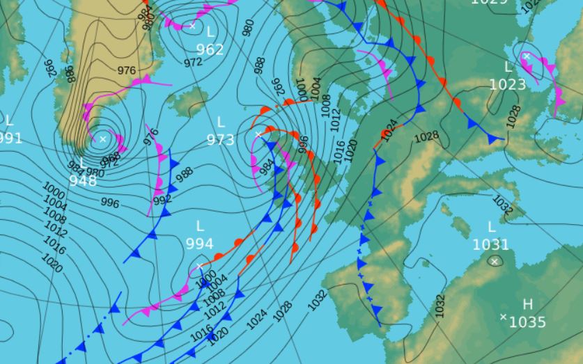
The 28th was another wet day, 27.0 mm, mainly falling during the afternoon, but topped up by storm 'Gertrude' overnight into the 29th. Gertrude passed to our NW, but which carried rain and strong winds on its southern flank, wind gusting to 60 Mph.
A cooler day came on the 30th with a little snow in the form of showers, as behind the cold fronts associated with Gertrude we sat in an unstable and much fresher WSW-ly flow. The month then ended with the temperature back on the rise as an occlusion from the SW brought a little rain - but out in the Atlantic storm 'Henry' was developing to welcome in February and that sense of 'Will it ever end?' rumbled on.
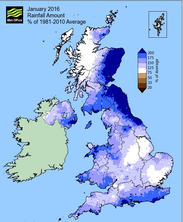
Rainfall totalled 195.1 mm for the month, with rain recorded on 26 days of which 21 were 'Wet days' (1.0mm +).
The Mean Temperature for the month was 4.41°c -- The Mean Max' was 6.90°c -- The Mean Min' 1.93°c.
We had 8 Air Frosts in the month (year 8) -- Grass frosts totalled 18 (year 18).
The 1 foot soil temp ranged from a low of 2.5°c on the 18th to a high of 6.8°c on the 26-27th -- with a monthly mean of 5.0°c
The 1 meter soil temp ranged from a low of 5.8°c on the 23rd-24th to a high of 8.0°c on the 1st -- with a monthly mean of 6.9°c
COMPARISONS:-
* January 2016 rainfall was 124.3% of the January average for 2008 - 2015
* January 2016 was 1.48°c warmer than the January average for 2009 - 2015 and 0.8°c warmer than the local long term average 1981-2010
JANUARY 2010
FEBRUARY 2010
MARCH 2010
APRIL 2010
MAY 2010
JUNE 2010
JULY 2010
AUGUST 2010
SEPTEMBER 2010
OCTOBER 2010
NOVEMBER 2010
DECEMBER 2010
JANUARY 2011
FEBRUARY 2011
MARCH 2011
APRIL 2011
MAY 2011
JUNE 2011
JULY 2011
AUGUST 2011
SEPTEMBER 2011
OCTOBER 2011
NOVEMBER 2011
DECEMBER 2011
JANUARY 2012
FEBRUARY 2012
MARCH 2012
APRIL 2012
MAY 2012
JUNE 2012
JULY 2012
AUGUST 2012
SEPTEMBER 2012
OCTOBER 2012
NOVEMBER 2012
DECEMBER 2012
SUMMER 2012
REVIEW OF 2012
JANUARY 2013
FEBRUARY 2013
MARCH 2013
APRIL 2013
MAY 2013
JUNE 2013
JULY 2013
AUGUST 2013
SEPTEMBER 2013
OCTOBER 2013
NOVEMBER 2013
DECEMBER 2013
REVIEW OF 2013
JANUARY 2014
FEBRUARY 2014
MARCH 2014
APRIL 2014
MAY 2014
JUNE 2014
JULY 2014
AUGUST 2014
SEPTEMBER 2014
OCTOBER 2014
NOVEMBER 2014
DECEMBER 2014
WINTER 2014
REVIEW OF 2014
JANUARY 2015
FEBRUARY 2015
MARCH 2015
APRIL 2015
MAY 2015
JUNE 2015
JULY 2015
AUGUST 2015
SEPTEMBER 2015
OCTOBER 2015
NOVEMBER 2015
DECEMBER 2015
REVIEW OF 2015
© Darren Rogers 2016
Want to comment on this site? email